




El Niño Drives Unprecedented Hurricane Activity in Eastern Pacific Amid Quiet Atlantic Season

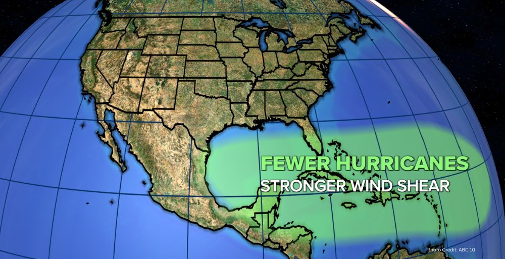
The ongoing El Niño phenomenon is significantly influencing weather patterns worldwide, with notable increases in hurricane activity in the eastern Pacific and a contrasting calm in the Atlantic.
The climatic phenomenon known as El Niño is currently reshaping weather patterns globally, particularly evident in the eastern Pacific, where an unusually active hurricane season is underway. As of mid-September 2023, the eastern Pacific has recorded 22 named storms, including 12 hurricanes, of which 10 are classified as major hurricanes. This level of activity exceeds the seasonal average and occurs with two months remaining in the official hurricane season, which typically concludes on November 30.
Understanding El Niño’s Impact on Hurricanes
El Niño conditions create a unique combination of atmospheric and oceanic factors that enhance storm formation. Specifically, these conditions feature elevated ocean temperatures and reduced wind shear, particularly in the upper atmosphere, which collectively facilitate the rapid strengthening of tropical storms. For example, Hurricane Polo, one of the most notable storms of this season, underwent rapid intensification, achieving wind gusts of 180 mph (285 km/h). This robust development was fueled by exceptionally warm waters resulting from El Niño.
Polo’s significant strength was observed alongside two other hurricanes, Odalys and Nolo, both active in the same basin simultaneously. This occurrence has been particularly notable, marking the second instance within a month of three concurrent hurricanes in the eastern Pacific. Earlier in September 2023, the same region witnessed the simultaneous presence of Hurricanes Lowell, Karina, and Marie. This phenomenon of multiple hurricanes occurring together is rare; the last recorded instance prior to this year was in 2015, highlighting the increasing volatility and intensity tied to the current El Niño event.
Contrasting Conditions in the Atlantic Ocean
In stark contrast to the eastern Pacific, the Atlantic Ocean has experienced an unusually quiet hurricane season. Generally, El Niño events are known to increase wind shear in the North Atlantic, a phenomenon that disrupts storm formation and development. This year, only Hurricane Isaias has made landfall, impacting the Florida Panhandle and Alabama. Notably, Isaias formed later in the season than any other recorded hurricane since the advent of satellite monitoring in the 1960s, with its formation occurring after September 11. This date surpasses the previous record for the latest-forming hurricane, which had been set on September 11 in both 2002 and 2013.
In a typical Atlantic hurricane season, one would expect to see approximately 10 named storms, five hurricanes, and two major hurricanes by mid-September. However, as of this writing, only eight tropical storms have been recorded in the Atlantic: Arthur, Bertha, Cristobal, Dolly, Edouard, Fay, Gonzalo, and Hanna. This sharp deviation from the norm raises questions regarding the broader implications of the current El Niño event and its influence on hurricane activity.
Historical Context of El Niño Events
Historically, El Niño events have been associated with significant changes in global weather patterns. These cyclical phenomena typically occur every two to seven years and can persist for several months, impacting weather systems both locally and globally. The current El Niño is expected to persist into the winter months, which could lead to further anomalies in weather patterns worldwide, including variations in precipitation and temperature across various regions.
The implications of El Niño’s influence on global weather are critical for scientists and policymakers alike. The phenomenon is known to disrupt typical weather patterns, which can have cascading effects on agriculture, water supply, and disaster preparedness in various regions. For instance, areas that rely on predictable weather for farming may encounter significant challenges due to altered precipitation and temperature patterns associated with El Niño.
Future Implications and Preparedness
The ongoing developments in both the eastern Pacific and the Atlantic are crucial for understanding the broader impacts of the current El Niño event. The substantial variations in hurricane activity observed this year underscore the need for continuous research and preparedness strategies, especially as global climate dynamics evolve. Meteorologists and climate scientists are closely monitoring these trends, recognizing that the interplay between El Niño and hurricane activity is complex and multifaceted.
In addition to immediate weather-related impacts, the long-term climate trends influenced by El Niño could necessitate adjustments in how regions prepare for and respond to natural disasters. The increased frequency and intensity of storms, particularly in the eastern Pacific, could strain emergency response systems and necessitate more robust infrastructure to withstand extreme weather events.
As we move further into the hurricane season, the contrasting effects of El Niño on the eastern Pacific and the Atlantic will continue to be a focal point for meteorological research and public policy. Understanding the dynamics of this climatic phenomenon is essential for developing effective strategies to mitigate its impacts on communities, economies, and ecosystems worldwide.





No Comment! Be the first one.