




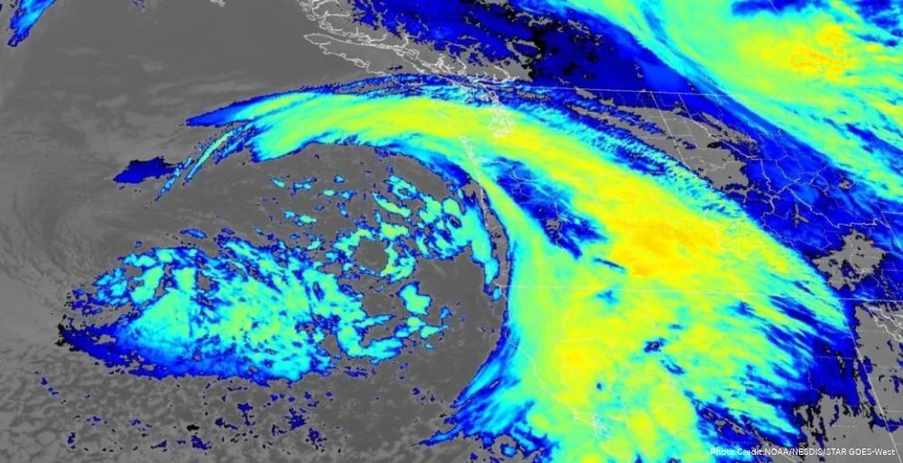
This winter marks the arrival of the first major atmospheric river impacting the West Coast, bringing significant rainfall, heavy mountain snow, and isolated tornado threats.
This winter season has commenced with a notable climatic event as the first major atmospheric river is currently affecting the West Coast of the United States. This storm, characterized by its capacity to deliver intense rainfall, substantial snowfall in mountainous areas, and the possibility of isolated tornadoes, is being closely monitored by meteorologists and weather agencies.
The National Weather Service (NWS) has identified this atmospheric river as part of a larger weather pattern associated with El Niño, a climatic phenomenon that is expected to influence weather across the region throughout the winter months. Recent reports indicate that this atmospheric river is intensifying, with California anticipated to bear the brunt of its impact while also affecting neighboring states such as Nevada, Utah, and western Colorado, which have been grappling with drought conditions.
Current Weather Forecasts
According to the latest forecasts, the atmospheric river is expected to drive significant weather activity across California and the Pacific Northwest, particularly today. The NWS has indicated that the heaviest precipitation will likely occur along the coast and in the foothills, with central and southern California facing an increased risk of flash flooding on Wednesday and Thursday. This follows a series of storms that have already impacted the Pacific Northwest, underscoring the ongoing influence of atmospheric rivers on regional weather patterns.
In the Sierra Nevada mountain range, snowfall accumulations could reach up to four feet (1.2 meters), marking a significant contribution to the snowpack that is vital for California’s water supply. Last week’s storms had already begun to replenish the Sierra Nevada’s snowpack, adding nearly a foot (30 centimeters) at Donner Pass and resulting in the temporary closure of Interstate 80 due to hazardous travel conditions. The NWS has warned that the combination of heavy snowfall and gusty winds could lead to dangerous travel situations and reduced visibility across various regions.
Potential Thunderstorms and Tornadoes
In California’s Central Valley, meteorologists are closely watching the development of strong to severe thunderstorms, particularly on Thursday afternoon. Local weather expert Chris Nunley has indicated that under the right atmospheric conditions, there is a possibility of large hail, strong wind gusts, and even brief tornadoes. However, he cautioned that persistent cloud cover and rain could hinder daytime heating, which may reduce the overall likelihood of severe weather occurrences.
Earlier this week, two waterspouts formed over San Francisco Bay, attributed to the interaction of cold, moist air with unusually warm sea surface temperatures. The waters off the Pacific Coast, particularly in California, have been experiencing record-breaking temperatures, largely due to the current El Niño conditions. This warming has significant implications for the atmospheric patterns and storm systems forming in the region.
Understanding the El Niño Impact
The current atmospheric river is a striking indicator of the potential impacts of a strong El Niño winter. Climate scientist Daniel Swain from the University of California Agriculture and Natural Resources noted that the most significant aspect of this storm is the rapid intensity of rainfall, with most of the total accumulation expected to occur within a short time frame. This phenomenon is largely due to a moderately strong cold front interacting with excess moisture and heat along the coast, exacerbated by a severe marine heatwave.
Swain emphasized that the significant moisture levels associated with this storm could become a defining characteristic of weather events throughout this particularly strong El Niño winter. He noted that while El Niño generally increases the likelihood of wetter-than-normal winters in Southern California, it does not guarantee that every storm will follow this pattern.
Furthermore, climate scientist Julie Kalansky from the Scripps Institution of Oceanography highlighted the inherent variability in weather patterns, stating, “Even though we see these general patterns during El Niño and La Niña years, there is still a lot of variability, and not every event is going to follow the general pattern.” She reiterated that although the declaration of an El Niño suggests a tendency toward wetter conditions, it does not ensure that Southern California will experience a consistently stormy winter.
Looking Ahead: Future Weather Patterns
As the El Niño phenomenon continues to strengthen, meteorologists predict that its most significant effects will unfold between January and March. However, the current atmospheric river impacting the West Coast may serve as an early indicator of the challenges and weather conditions that lie ahead for the region. The interplay of these weather systems will be critical in determining how the winter progresses, particularly regarding precipitation patterns and their implications for water resources in California and surrounding states.
In conclusion, the first major atmospheric river of the season heralds a dynamic winter for the West Coast. As weather agencies and scientists continue to monitor the situation closely, the impacts of El Niño remain a focal point for understanding the evolving weather patterns expected in the coming months.



No Comment! Be the first one.